(707) 839-5130 | Contact Us
Slope Stability Modeling in Freshwater Creek and Ryan Creek
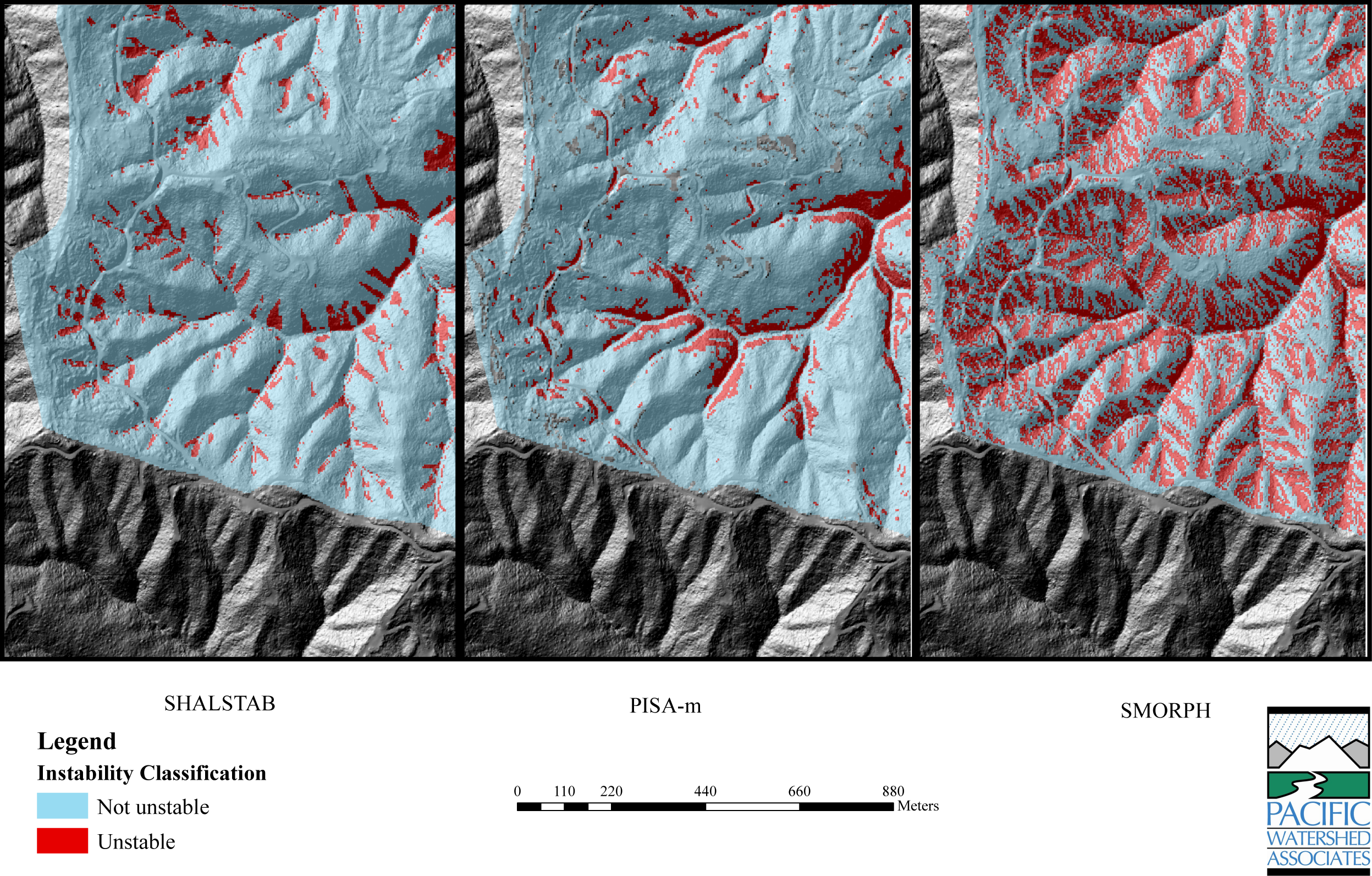
Comparison of slope stability predictions from 3 different GIS-based models.
Summary:
PWA evaluated the utility of 3 GIS-based slope stability models for predicting mass-wasting susceptibility in Freshwater Creek and Ryan Creek watersheds.
Client:
North Coast Regional Water Quality Control Board
Location:
Humboldt County, California
Project Lead (s):
Eileen Weppner Project Gallery:

Three spatially distributed slope stability models (SHALSTAB, PISA-m, and SMORPH) were employed utilizing a 1-m LiDAR DEM of two Northern California coastal watersheds (Freshwater Creek and Ryan Creek) as part of an EPA Total Maximum Daily Load Study (TMDL). The model outputs were intended to assist in categorizing the watersheds into landslide “hazard” or mass wasting susceptibility categories and ultimately provide a planning tool for resource agencies to identify potentially unstable areas, and provide guidance with regards to future land management. The high-resolution 1-m DEM caused the SHALSTAB modeling program to crash in a previous landslide hazard study. As a result, the 1-m DEM was resampled to a 4-m DEM using bilinear interpolation in order to “smooth” the data.
The performance of each model was evaluated by comparing model outputs to air photo identified landslide inventories, and comparing the models to each other to determine how well they predicted air photo identified landslides and the degree of model overlap of unstable and stable areas. Overall, the SMORPH model correctly predicted the highest percentage (99%) of air photo identified landslides. Although the SMORPH model appears to be a “good” predictor of landslide occurrence, the model identified more than 3 times the area of unstable slopes in comparison to the other 2 models. As a result, the SMORPH model overestimated the area of unstable slopes in the study area. Both SHALSTAB and PISA-m models correctly identified 75% of the air photo identified landslides. SHALSTAB and PISA-m models exhibited only 25% of overlap of unstable areas classified by each model type. The low percentage of overlap between the SHALSTAB and PISA-m models may be due to the difference in the application of infinite slope equations by each model. Nearly 60% of the slopes classified as unstable by the SMORPH model exhibited no overlap with the other two models. Of the 3 models evaluated, the SHALSTAB and PISA-m models used in combination with more traditional geomorphic analyses and field-based observations may provide an accurate landslide hazard zonation for the study area.
Services Rendered :
- 13 of 26
- Projects:
- ‹ previous
- next ›
